Integration of IoT for Sensor Connectivity and Asset Management in a Digital Mine
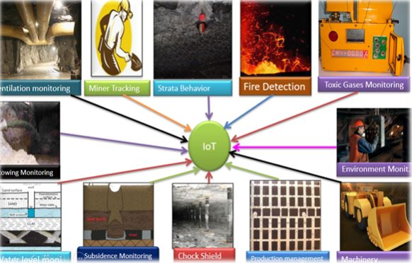
This solution aims to develop a ‘Digital Mine’ with the help of data from different sensors, integrating all the sensor data, managing assets, and generating relevant studies for effective mine management, safety, and disaster mitigation. The study aims to provide a comprehensive understanding of the different phases and modules required for the development of the said digital mine. The processes include acquisition, processing, storing and management of information on geological features, mining activities, mine hazards, ventilation, safety, rescue operation, production, miners tracking, etc. Real-time monitoring and prediction of fatal accidents for taking precautionary measures in advance to avoid loss of lives of miners as well as mine’s property is an important aspect of this solution.
Integration Phases and Deployment
Phase 1: As-Built Information Capture:
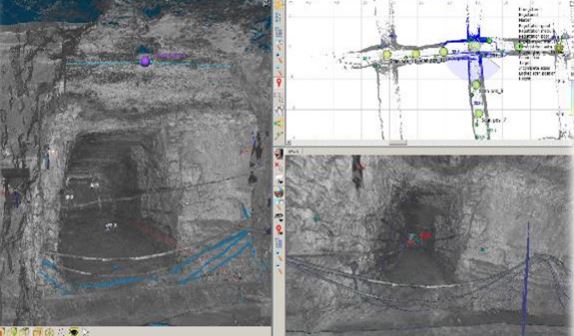
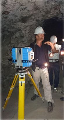
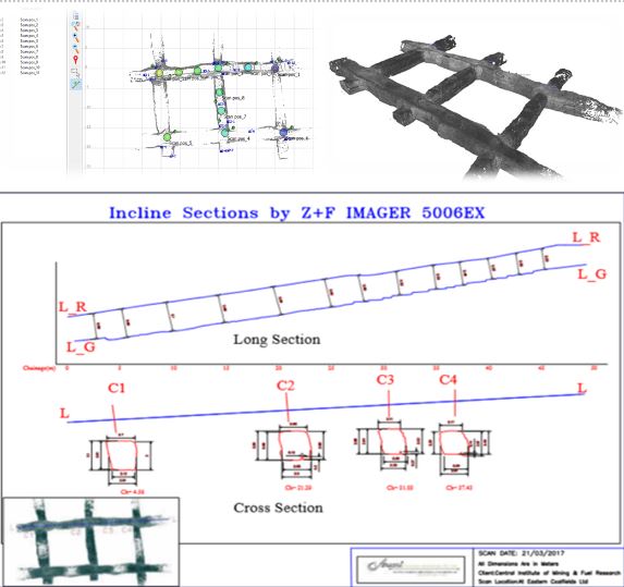
Phase 1 of the proposed development of the Digital Mine focuses on the capture of As-Built Information using an ATEX Certified Explosion Proof Z+F 3D LiDAR Scanner. This phase is crucial for ensuring the reliability, quality, and accuracy of the digital mine. In underground mine environments, special care needs to be taken to collect the As-Built Information due to the potentially explosive nature of the surroundings. The ATEX certified LASER Scanner ensures the safety of engineers while collecting accurate data that may be inaccessible through other mapping methods such as handheld scanners or Total Station. The main objective of Phase 1 is to capture detailed and precise information about the physical mine. This includes geological features, mining activities, mine hazards, ventilation, safety measures, rescue operations, production data, and miners' tracking. By acquiring this information, real-time monitoring and prediction of fatal accidents can be achieved, allowing for proactive measures to be taken to prevent loss of lives and property. The captured As-Built Information serves as the foundation for the subsequent phases of the digital mine development. It provides the necessary data for the preparation of existing and proposed plans, which will be integrated to create a combined view of the mines. This integration allows for better visualization, analysis, and decision-making regarding the mine's operations and management.
Phase 1 also emphasizes the importance of storing and managing the captured data in a structured and efficient manner. This requires the development of a 3D Mine Visualizer Software, which will serve as the heart of the Digital Mine. The software will include modules such as 3D Visualizer, 3D Planner, Asset Database, Sensor Connect (IoT/Manual), Personnel Locator, Alert Manager, MIS Reports, CAD tools, and Historical Data Manager. These modules will enable the analysis, visualization, and utilization of the collected information for effective mine management. In summary, Phase 1 of the proposed Digital Mine development focuses on capturing accurate As-Built Information using an ATEX certified LASER Scanner. This information forms the basis for subsequent phases and enables real-time monitoring, analysis, and decision-making for improved mine safety, productivity, and efficiency.
Phase 2: Preparation of As-Built and Proposed Plans:
In Phase 2 of the proposal, the focus is on preparing the As-Built and Proposed plans for the Digital Mine project. The activities in Phase 1 involve generating high-density, information-rich, and accurate 3D LiDAR points that are then imported into a CAD system. The As-Built data is captured in a CAD environment with the assistance of an experienced Mine Engineer. This As-Built information is crucial as it needs to be integrated with the proposed plans to provide a comprehensive view of the mines.
The document mentions that the output from an ATTIX Certified LASER Scanner is ready for drafting, indicating the use of advanced technology for data collection. The sample plan of an underground mine is also provided as a reference point.
Furthermore, it emphasizes the importance of storing captured data in a structured manner for easy accessibility and analysis by individuals without specialized technical knowledge. To achieve this, the proposal suggests the development of a 3D Mine Visualizer Software that includes essential software modules such as 3D Visualizer, 3D Planner, Asset Database, Sensor Connect (IOT/Manual), Personnel Locator, Alert Manager, MIS Reports, and CAD tools.
Overall, Phase 2 sets the foundation for combining the As-Built data with the proposed plans to create a comprehensive view of the mines, facilitating better management and control of the mining operations.
Phase 3: Sensor Integration and Asset Management:
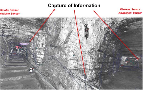
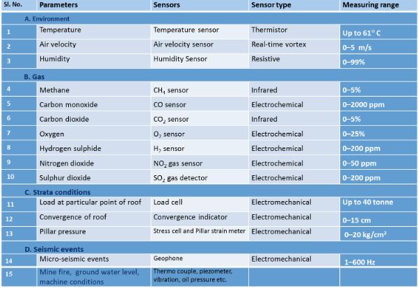
Phase 3 of the proposal focuses on the deployment of sensors in the Digital Mine setup. Sensors play a vital role in providing real-time data and insights into the mine environment, allowing engineers to understand the situation within the mines effectively. CIMFR is designing specific sensors tailored for the mine environment in India and integrating them as IoT devices that can communicate over the Internet or Intranet using LAN/WiFi modules.
The IoT devices are designed to communicate with the sensors using various interconnect protocols and technologies such as I2C, SPI, UART, CAN bus, LIN, RF, Bluetooth, among others. Additionally, RFID tags are planned to be attached to every miner and movable asset, with Fixed Mount Readers & Antennas installed at zone entrances for monitoring personnel and asset locations.
The information collected from these sensors and equipment will be monitored remotely via Ethernet, providing valuable data for location monitoring of personnel and assets. In the event of a disaster, this data will be crucial for rescue and recovery operations. Each fixed sensor deployed will have unique IDs and will be digitized with XYZ coordinates in the plan, connected to the main database monitored in the control room.
Phase 3 underscores the significance of sensor deployment in ensuring the safety, efficiency, and monitoring of the mine environment. By leveraging advanced sensor technologies and IoT devices, the Digital Mine project aims to enhance real-time data collection, monitoring, and response capabilities within the mining operations.
Phase 4: Digital Mine- 3D Mine Visualizer Software:
Phase 4 of the proposal focuses on the development of the Digital Mine, which is a critical component of the overall project. This phase involves the creation of a 3D Mine Visualizer Software that integrates data from the previous three phases and provides primary analysis of information for automated alerts, production optimization, safety enhancements, disaster mitigation, and overall mine maintenance.
The software developed in this phase acts as the heart of the Digital Mine, where all captured information is analyzed and visualized. It is proposed that the software be developed on the Windows platform with data connections to a centralized database of geospatial information. The software will store output from different sensors, scanners, design software, and other static and dynamic information in a structured manner for easy access and analysis.
The 3D Mine Visualizer Software will assist users in analyzing complex scenarios, providing information in the event of a disaster to rescue teams, generating concise and detailed reports for management, and aiding in the maintenance of the mine. It will also facilitate real-time monitoring and prediction of fatal accidents, enabling precautionary measures to be taken in advance to avoid loss of lives and property.
Overall, Phase 4 is crucial for the successful implementation of the Digital Mine project, as it involves the development of software that consolidates and analyzes data from various sources to enhance safety, efficiency, and decision-making within the mining operations.
Key Features
Visualization: Displaying mine structures, tunnels, galleries, assets, and geological formations in a visually appealing and intuitive 3D format.
Navigation: Offering tools for easy navigation through the mine site, enabling users to explore different areas and viewpoints.
Measurement Tools: Providing tools for measuring distances, volumes, and other spatial parameters within the 3D environment.
Interconnectivity: Allowing seamless integration with other software modules within the Digital Mine system for data sharing and analysis.
User-Friendly Interface: Offering a user-friendly interface that facilitates easy interaction and manipulation of 3D visualizations.
Data Integration: Integrating data from various sources, such as sensors, scanners, and CAD files, to create a comprehensive and accurate representation of the mine.
Phase 5: Virtual Reality Visualization and SCADA System:
Phase 5 of the proposal focuses on the establishment of a control room equipped with Virtual Reality (VR) technology and a Supervisory Control and Data Acquisition (SCADA) system. The control room serves as a central hub for monitoring and managing the Digital Mine operations effectively.
The control room setup includes servers, networks, databases, display systems, control systems, communication equipment, and other essential infrastructure. It operates 24/7 to monitor daily production, detect potential disasters, analyze operational shortcomings, and ensure the overall safety and efficiency of the mine.
The details of Phase 5 are planned after the implementation and testing of Phase 4, indicating a sequential progression in the project development. The control room is designed to access data from multiple mines, enabling better management and control across various mining sites.
Furthermore, the control room integrates data from sensors, IoT devices, and other monitoring equipment to provide real-time insights into the mine's operations. It allows for remote monitoring of equipment, personnel, and assets, facilitating location tracking and ensuring swift response in case of emergencies or disasters.
In summary, Phase 5 emphasizes the importance of a well-equipped control room with VR technology and a SCADA system to enhance monitoring, control, and decision-making capabilities within the Digital Mine project. It serves as a central command center for overseeing mining activities, ensuring safety, and optimizing operational efficiency.