A laser-measurement-based monitoring system for long-range profiling of :
OPMMS automatically performs continuous remote scanning from designated permanent sites, comparing the obtained scans to a reference base scan and identifying displacements and changes. Within the inspected region, manual on-the-fly analysis and output (statistics, inspection maps, classification charts, displacement and displacement rate graphs across time intervals) are possible. Alerts and customizable notifications are sent via email and SMS. OPMMS is a complete time-tested solution from Gexcel Srl. that consists of a rugged terrestrial laser scanner that is entirely controlled by processing software built into a dedicated control unit.

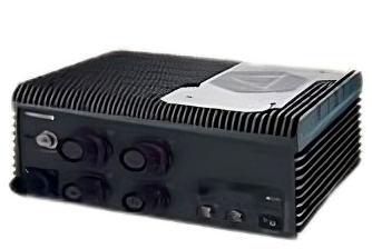
OPMMS is a full solution that includes:
|
OPMMS compares the acquired scans to a reference one and detects displacements and changes. Full control of acquisitions frequency. | OPMMS gives you the possibility to create a permanent setup with multiple regions of interest (ROIs) at different resolutions. | OPMMS allows further data investigations, such as volumetric computations or planning and analysis of excavation processes. |
Customize monitoring frequency and set notification thresholds, identify trends and watch multiple areas. Automatic notifications via Email and SMS.
Safely survey pit high walls, rock falls, landslides, and glaciers. Risky areas are reported to the supervisors who can plan further onsite analysis with geotechnical teams, engineers and topographic surveyors.
Compare accurate volumes and get the areas’ 3D models.
Maintain 24/7 surveillance in harsh situations to ensure safe mining operations.